The National Park of American Samoa is one of the most remote and seldom visited properties in the national park system. A tropical paradise, the park welcomes visitors eager to discover and explore the culture and habitat of the South Pacific. It is best known for its secluded villages, tropical rain forests, rare plants and animals, coral reefs, sand beaches, and vistas of land and sea. The park was established on 31 October 1988.
The Samoan archipelago is a typical volcanic island arc made up of seven islands and atolls located about 2600 miles (4184 kilometers) southwest of Hawaii. The National Park of American Samoa has an area of 13,500 acres, with 9,000 acres located on parts of three islands and an additional 4500 acres of ocean, coral reefs, and underwater habitat.
The most visited section of the park is at the north end of Tutuila, near Pago Pago and the park visitor center. It is the only unit accessible by car. The western part of the unit is comprised of a knifelike ridge leading up to the summit of Mount Alava, elevation 1610 feet (461 meters). The eastern part of the unit includes There are also World War II gun placements at Breakers Point and Blunt’s Point.
The Ta’u unit is the park’s largest, occupying the entire southeast corner of the island, including impressive Lata Mountain. At 3,169 feet (966 metrs) it is the highest peak in American Samoa. Take in the beauty of Laufuti Falls and the sea cliffs. Be sure to stop at the Saua archaeological site, one of the most important Samoan cultural places, where the supreme god Tagaloa is said to have created the first humans.
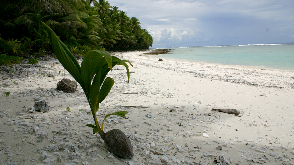
The Ofu unit has the kind of picturesque white, sandy beach that screams tropical paradise. Enjoy the solitude, snorkeling, and nearby coral reefs.
Physical Address
National Park of American Samoa
MHJ Building, 2nd Floor
Pago Pago, AS 96799
Hours of Operation
National Park of American Samoa is open 24 hours, every day of the year. There are no entrance fees or passes required to visit the park. Temporary closures are of some parts of the park sometimes occur due to maintenance or safety issues. Please check with the park about conditions prior to your visit. National Park of American Samoa is located in the Samoa Standard Time Zone (UTC/GMT -11).
Please note: American Samoa does not observe daylight savings time.
Entrance Fees
(2018 Season)
There are no entrance fees at this national park.
All passes are waived.
Lodging and Camping in the Park
There are no campgrounds or hotels inside the park.
Home stays are available in several areas in and around the park on Tatuila, Manu’a and Olosega Islands. These are popular options and a wonderful way to experience Samoan lifestyle and culture first hand. The national park provides information and contact details for home stay opportunities, but visitors must contact the home stay hosts and negotiate their own arrangements with home stay families. [Learn more]
Contacting National Park of American Samoa
Mailing Address:
National Park of American Samoa
MHJ Building, 2nd Floor
Pago Pago, AS 96799
Park Headquarters: +1 (684) 633-7082 x22
Email: npsa_info@nps.gov
Website: National Park of American Samoa
Park Highlights Driving Tour
Petrified Forest National Park offers a well organized driving tour taking visitors to all of the most important features of the park. The whole drive can be completed in about 3-4 hours including short stops at each location, but to get the most enjoyment out of the tour you might want to allow a whole day and include some of the short hikes and supplemental road loops along the way.
At the north end of the park, the driving tour starts at the Painted Desert Visitor Center. This itinerary may be driven in reverse starting from the Rainbow Forest Museum and Visitor Center at the south entrance to the park.
- Painted Desert Visitor Center
- Painted Desert Inn
- Painted Desert Overlooks
- Route 66 Alignment
- Puerco Pueblo
- Newspaper Rock
- Blue Mesa
- Agate Bridge
- Jasper Forest
- Crystal Forest
- Rainbow Forest Museum and Giant Logs Trail
- Long Logs and Agate House
Developed Trails in Petrified Forest National Park
Painted Desert Rim Trail: 1 mi (1.6 km) round trip A walk between Tawa Point and the Painted Desert Inn, offering scenic views of the Painted Desert below.
Puerco Pueblo Trail: 0.3 mi (0.5 km) loop A short walk among Native American village remains dating from 1250-1380 CE. Interpretive signs.
Blue Mesa Trail: 1 mi (1.6 km) loop Explore the vibrant blue, purple and gray of these badlands dotted with colorful petrified wood.
Crystal Forest Trail: 0.75 mi (1.2 km) loop Wander around a large field of colorful petrified logs.
Giant Logs Trail: 0.4 mi (0.6 km) loop Impressive collection of large logs. Showcase specimen Old Faithful measures nearly 10 ft across at the base. Trail guide available.
Long Logs Trail: 1.6 mi (2.5 km) loop Site of a Triassic Era log jam with many long petrified tree trunks.
Agate House Trail: 2 mi (3.3 km) round trip Visit an eight room reconstructed pueblo constructed almost entirely out of petrified wood.
The Long Logs and Agate House trails start from the same trailhead and may be combined for a longer 2.6 mi (4.2 km) hike.
Backcountry Hiking in Petrified Forest National Park
Hoping to avoid the crowds? There are over 50,000 acres of wilderness waiting to be explored in the Petrified Forest National Park. Go off the beaten track onto an old road or unmaintained trail, or use map and compass to blaze a new path. More information available at the Painted Desert Visitor Center, Rainbow Forest Museum, or online at the National Park Service website.
Top 5 Off the Beaten Path Hikes
Old Blue Forest 2.4 mi (3.9 km) round trip Hike along an unmaintained CCC trail. Enjoy huge petrified logs, desert landscape. [NPS route guide]
Jasper Forest 2.5 mi (4 km) round trip Hike along an old 1930s road through a garden of petrified wood. [NPS route guide]
Onyx Bridge 4 mi (6.4 km) round trip Leaves from Painted Desert Inn. See how a 210 million year old fallen tree forms a natural bridge. [NPS route guide]
Billings Gap 3 mi (4.8 km) round trip Hike to the Billings Gap overlook for views across the badlands and grassy valleys. [NPS route guide]
Martha’s Butte 2 mi (3.2 km) round trip Walk through wash country to the butte and a solar petroglyph. [NPS route guide]
I am text block. Click edit button to change this text. Lorem ipsum dolor sit amet, consectetur adipiscing elit. Ut elit tellus, luctus nec ullamcorper mattis, pulvinar dapibus leo.
Safety Tips for Visitors to the National Park of American Samoa
There are few health risks for normal, healthy people visiting the park. Nevertheless, it is better to be safe than sorry. Here are some tips to help you stay safe and out of trouble.
General Safety Tips for Park Visitors
Solar radiation is intense! Wear sunglasses, sunscreen, a hat, and protective clothing. Treat every day as a potential sunburn risk
Carry insect repellent, especially during the wet season.
Whatever you do, find a buddy. You never know what might happen, and it is always better to have help around when problems arise.
Beware of dogs! People do get bitten.
Medical treatment is limited on Tutuila, and even more so on the other islands.
Bring with you any regular medications you might need. Access to prescription drugs is limited on the islands.
Beach Safety Tips:
Watch out for falling coconuts when in beach areas.
Learn to swim. This is the best and most important safety tip for people who love the beach.
Non-swimmers, weak swimmers, and other at risk individuals should bring and and use appropriate water safety equipment.
Do not leave children near water unattended.
Be aware of the tidal movements and be alert for dangerous waves, tidal outflows, rip tides, and undertows. Do not underestimate the power of the ocean.
Beware of long exposure to the sun. Bring sunscreen and apply it liberally. Use a beach umbrella to shield yourself while resting on the beach.
Watch your step. Coral rubble beaches are difficult to walk on, and rocky areas can be slippery. Sunbaked sand can get blisteringly hot.
Don’t touch the coral, it is sharper than you think! Cuts and scrapes from coral take a long time to heal.
Hiking Safety Tips
Inquire at the visitor center about trail conditions before embarking on your hike.
Dress appropriately for the season and weather forecast. Good shoes, loose fitting clothes, protective sleeves and slacks, wind protection, rain gear and a hat are all good ideas for dealing with the variable weather of the Samoan Islands.
Always take water at least two liters of water with you for each person on the hike.
The Hawaii Pacific Parks Association is a cooperating nonprofit organization working with the National Parks in Hawaii and American Samoa. Founded in 1933, the association has a long history of assisting the Pacific Islands national parks in their mission to preserve, promote and protect the natural and cultural heritage of the region.
The association provides vital human, creative, and financial resources in a variety of ways that enhance the visitor experience and support the mission of the parks. For more information, contact the association through their website. Become a member or donate to their good work.
Hawaii Pacific Parks Association
P.O. Box 74
Hawaii National Park, HI 96718
Telephone: +1 (808) 985-6051
Fax: +1 (808) 985-7333
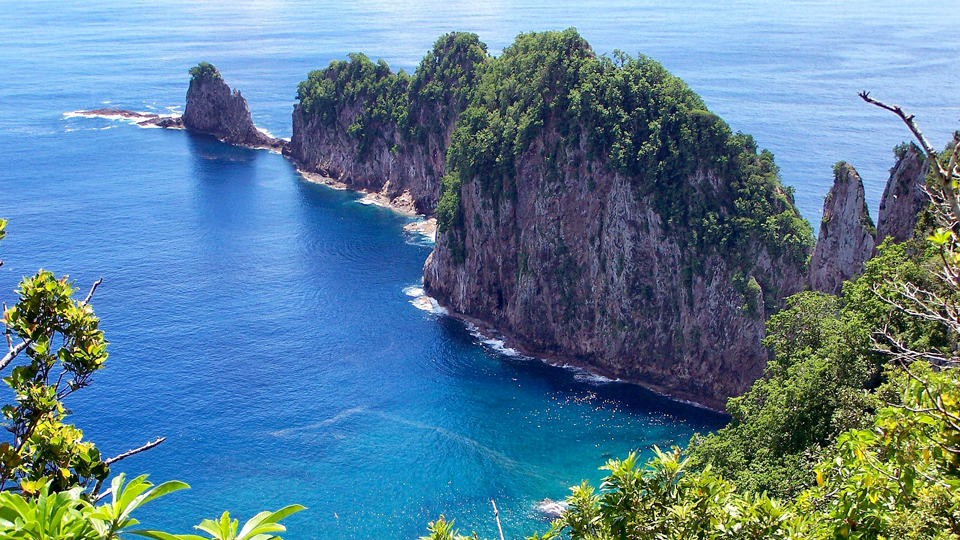
The best time to visit the National Park of American Samoa is during the dry season from June to September, when the weather is least hot and least rainy, and the threat of tropical storms is small.
That said, the islands enjoy fairly uniform temperatures with highs in the 80’s F. (30’s C.) year round and are comfortable any time of year. Just be sure to come prepared for sun, rain and humidity no matter when you plan to visit.
American Samoa is located in the South Pacific, with only limited connections to other islands, cities and countries. It can be reached by plane or boat from a variety of locations.
The National Park of American Samoa visitor center is located in the village of Pago Pago, across from the Pago Way Service Station. The national park is located in the villages of Vatia, Pago Pago, Fagasa, Afono (on Tutuila Island), Fitiuta, Faleasao (on Ta’u Island), and Ofu Island.
Arrival by Air
The nearest airport is Pago Pago International Airport (PPG) on Tutuila Island, about 30 minutes by car from the national park visitor center. The only direct commercial flights to the island are offered twice weekly from Honolulu (HNL) on Hawaiian Airlines (HAL).
More frequent service is available to nearby Faleolo International Airport (APW), the main airport serving Apia, the capital of (Western) Samoa. Faleolo is located on Upolu Island, about 100 miles (160 Kilometers) west of Pago Pago. Commercial flights are available on Air New Zealand (NZ) and Polynesian Airlines (PH) between Faleolo and destinations in Australia, New Zealand and Fiji.
Polynesian Airlines, Samoa Airways (OL) and Talofa Airways(TA) also offers flights between Pago Pago and Fagalii Airport in Apia, Samoa.
Small aircraft transport is available almost daily between Faleolo International and Pago Pago International.
Arrival by Boat
International ferry service is available between Pago Pago and Apia from the Samoa Shipping Corporation. Tickets are cheaper than flying, but the trip is basic and conditions rough, so most tourists fly between the islands.
Arrival by Car
You cannot drive to this park from anywhere else. It’s on an island!
The Tutuila unit of the park is the only one with car access, and it is also the most visited part of the park. There are rental car agencies in Pago Pago where you can rent a vehicle for getting around after you have made it that far.
GPS Coordinates
Park Headquarters
DD Coordinates: -14.2583333 -170.6833333
DMS Coordinates: -14°15’30.00″ S -170°40’60.00″ W
Geohash Coordinates: 2jqwuh25nn40y
UTM Coordinates: 2L 534158.6908854 8423679.7579937
I am text block. Click edit button to change this text. Lorem ipsum dolor sit amet, consectetur adipiscing elit. Ut elit tellus, luctus nec ullamcorper mattis, pulvinar dapibus leo.
I am text block. Click edit button to change this text. Lorem ipsum dolor sit amet, consectetur adipiscing elit. Ut elit tellus, luctus nec ullamcorper mattis, pulvinar dapibus leo.
Visit These Amazing American National Parks
Acadia American Samoa Arches Badlands Big Bend Biscayne Black Canyon of the Gunnison Bryce Canyon Canyonlands Capitol Reef Carlsbad Caverns Channel Islands Congaree Crater Lake Cuyahoga Valley Death Valley Denali Dry Tortugas Everglades Gates of the Arctic Glacier Glacier Bay Grand Canyon Grand Teton Great Basin Great Sand Dunes Great Smoky Mountains Guadalupe Mountains Haleakala Hawaii Volcanoes Hot Springs Isle Royale Joshua Tree Katmai Kenai Fjords Kings Canyon Kobuk Valley Lake Clark Lassen Volcanic Mammoth Cave Mesa Verde Mount Rainier North Cascades Olympic Petrified Forest Pinnacles Redwood Rocky Mountain Saguaro Sequoia Shenandoah Theodore Roosevelt Virgin Islands Voyageurs Wind Cave Wrangell-St. Elias Yellowstone Yosemite Zion
Just Browsing? Go back to the narangah Travel home page to uncover a wealth of travel information about destinations near and far. Imagine yourself there, and let us take you exploring around the world!+

